 UltraTrailPlan
Start a plan
Transylvania 100 - 100K 2027
Transylvania 100 - 100K 2027 is a 99.4 km (61.8 mi) trail race in Romania with 6,771 m (22,215 ft) of ascent and 6,764 m (22,192 ft) of descent. Race date: 29 May 2027. This page collects the public race facts, the route and elevation preview, and the aid stations and cutoffs from the UltraTrailPlan library.
Any race, not only this library. If you have the race’s GPX — usually from the organiser — load it from the home page to plan that race. The planner’s pacing, aid station, fuelling and cutoff tools work on the route you load; the strength is in the planner, and the library is a shortcut to the start.
Route and elevation
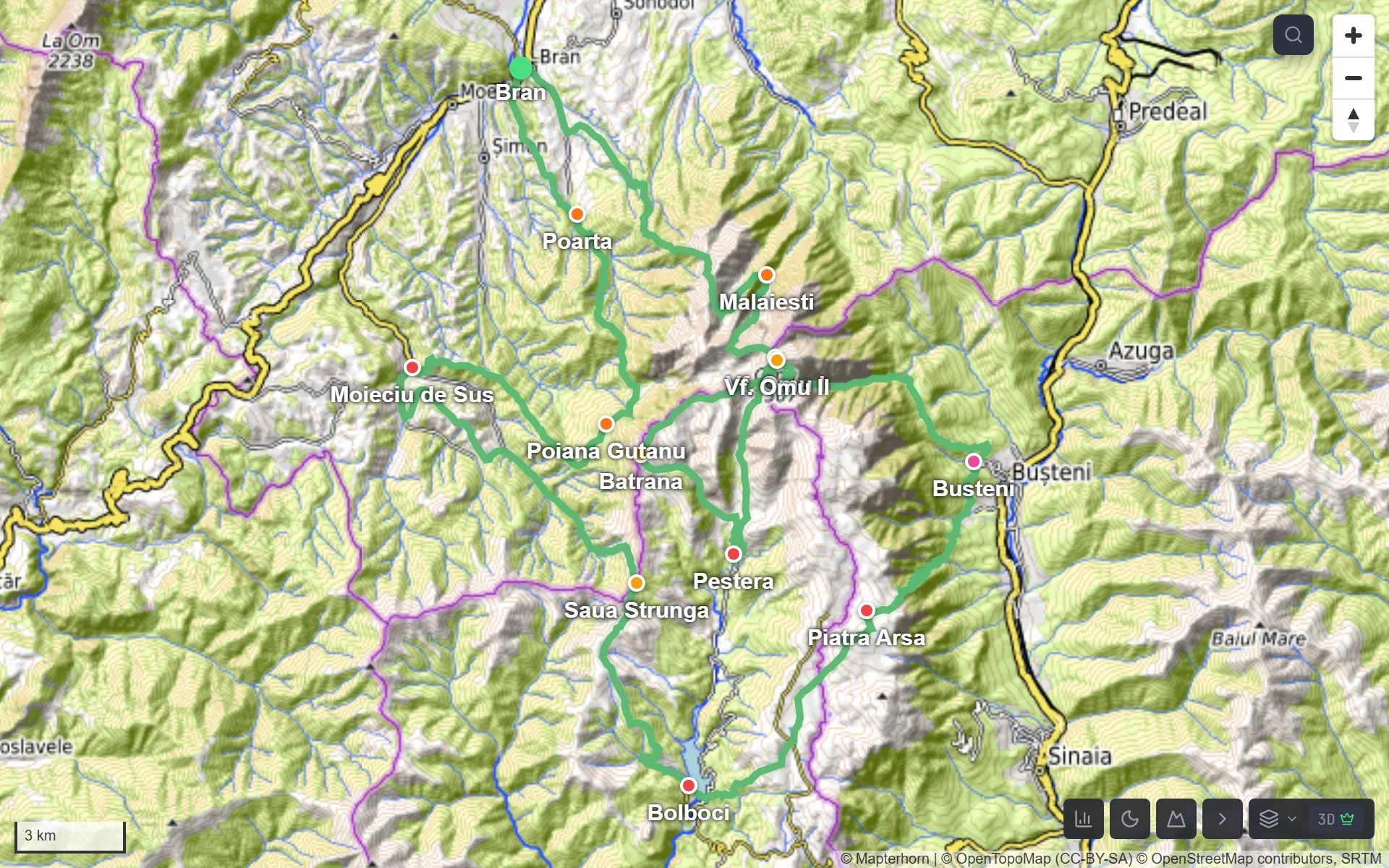
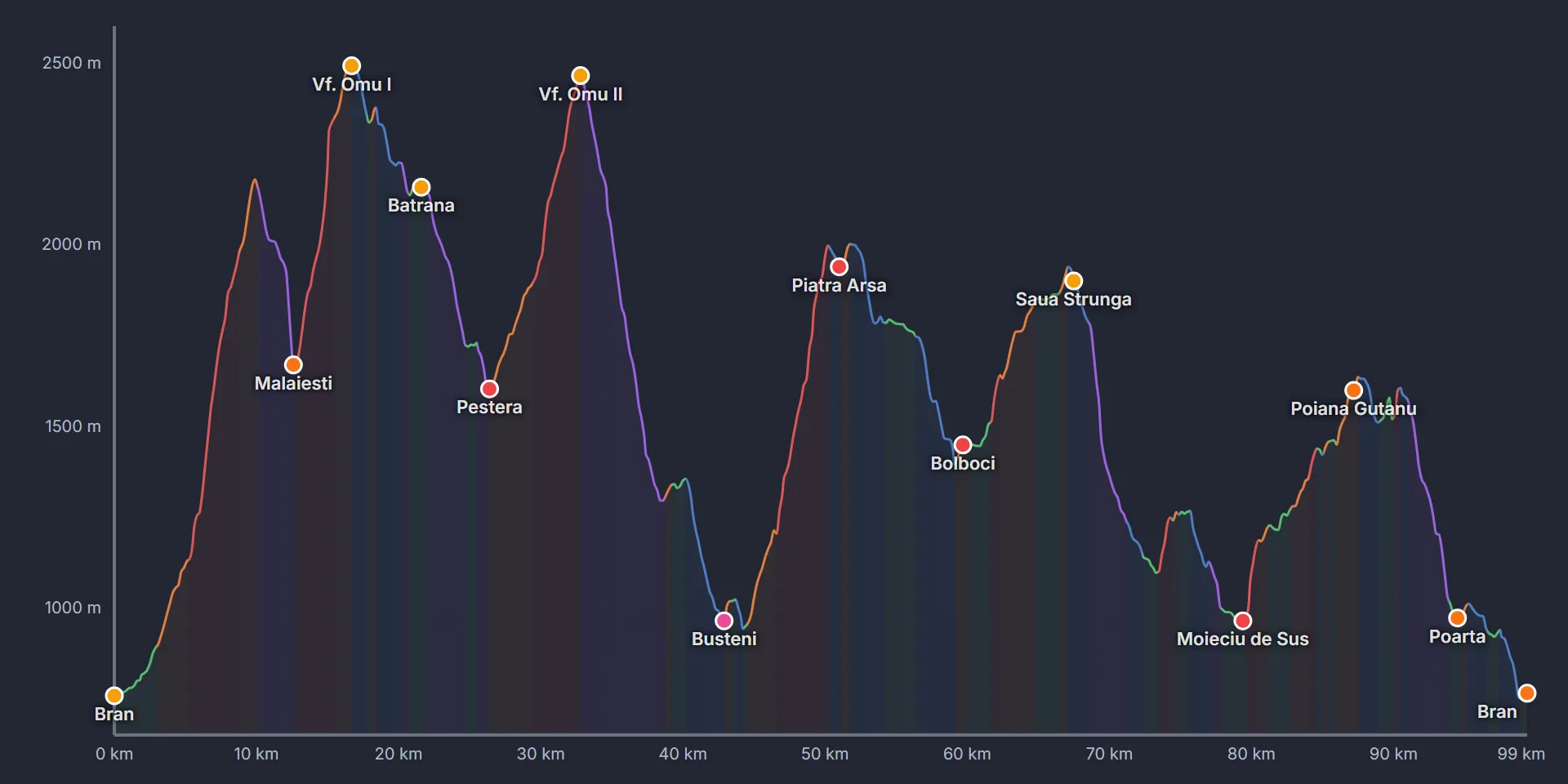
Map data © OpenStreetMap contributors, OpenTopoMap. Route and elevation previews are approximate, for planning only. The organiser’s route and profile are authoritative.
The route covers 99.4 km (61.8 mi) with 6,771 m (22,215 ft) of ascent and 6,764 m (22,192 ft) of descent. The images above show the route and elevation profile from the UltraTrailPlan planner.
Race facts
| Distance | 99.4 km (61.8 mi) |
|---|---|
| Ascent | 6,771 m (22,215 ft) |
| Descent | 6,764 m (22,192 ft) |
| Country | Romania |
| Date | |
| Year | 2027 |
| Tags | 100K, Carpathians, Romania |
| Climbing | 68 m/km (359 ft/mi) |
| Library tier | Free race |
| Aid stations | 14 |
| Race website | www.transylvania100k.com |
Aid stations and cutoffs
| Station | Distance | Cutoff | Services |
|---|---|---|---|
| Bran | 0 km (0 mi) | — | Checkpoint |
| Malaiesti | 12.7 km (7.9 mi) | 4:00 | Checkpoint, Hydration, Snacks |
| Vf. Omu I | 16.6 km (10.3 mi) | — | Checkpoint |
| Batrana | 21.6 km (13.4 mi) | — | Checkpoint |
| Pestera | 26.4 km (16.4 mi) | 7:00 | Checkpoint, Hydration, Snacks, Hot food |
| Vf. Omu II | 32.8 km (20.4 mi) | 10:30 | Checkpoint |
| Busteni | 42.9 km (26.7 mi) | 13:00 | Checkpoint, Hydration, Snacks, Hot food, Drop bag |
| Piatra Arsa | 50.9 km (31.7 mi) | 16:30 | Checkpoint, Hydration, Snacks, Hot food |
| Bolboci | 59.6 km (37 mi) | 19:00 | Checkpoint, Hydration, Snacks, Hot food |
| Saua Strunga | 67.6 km (42 mi) | — | Checkpoint |
| Moieciu de Sus | 79.3 km (49.3 mi) | 26:00 | Checkpoint, Hydration, Snacks, Hot food |
| Poiana Gutanu | 87.2 km (54.2 mi) | — | Checkpoint, Hydration, Snacks |
| Poarta | 94.6 km (58.8 mi) | — | Checkpoint, Hydration, Snacks |
| Bran | 99.4 km (61.8 mi) | 31:00 | Checkpoint, Hydration, Snacks |
Cutoff times come from the race entry in the UltraTrailPlan library. Most ultras set a cutoff as the time you must leave the station; a few apply it on arrival. Check the organiser’s rules: times can change, and confirm the definition for each station.
This page publishes the public race information held in the UltraTrailPlan library. It is not an official plan. The organiser’s route, aid stations, cutoffs and rules are authoritative. UltraTrailPlan is independent and not affiliated with any race or organiser. Route and terrain data include OpenStreetMap-derived content, available under the Open Database License.
Plan your pacing, aid stations and cutoffs for this race.
Plan this raceCite this page: “Transylvania 100 - 100K”, UltraTrailPlan, https://ultratrailplan.com/races/transylvania-100-2027-100k/.